22/07/2023
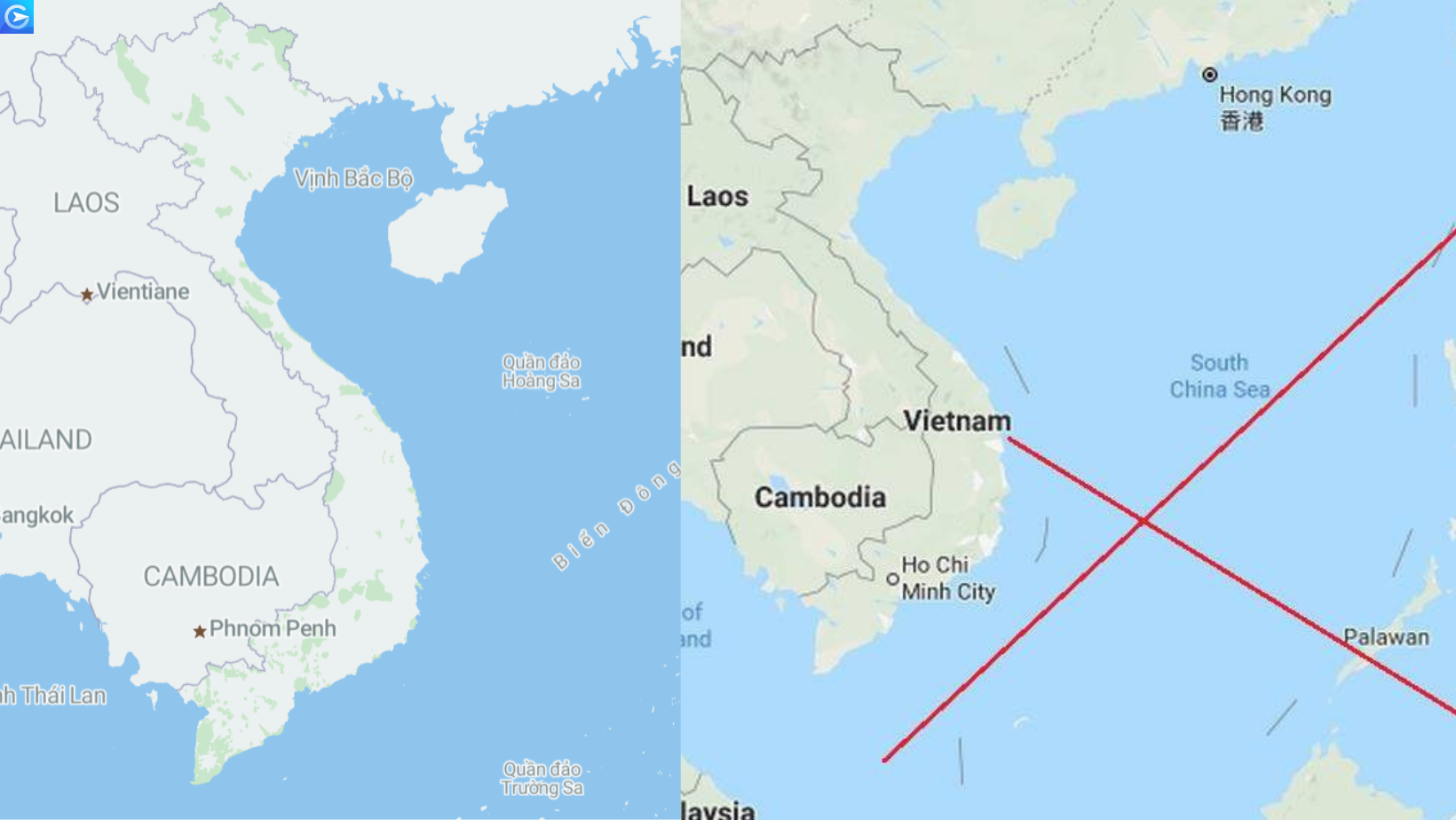
 Recently, the issue of certain organizations using inaccurate map data, which seriously violate Vietnam’s sovereignty and territorial integrity, has sparked great concern across all social forums and among the Vietnamese people. This has also sounded a warning bell to the authorities, indicating the need for stricter management measures and stronger sanctions against these violations.
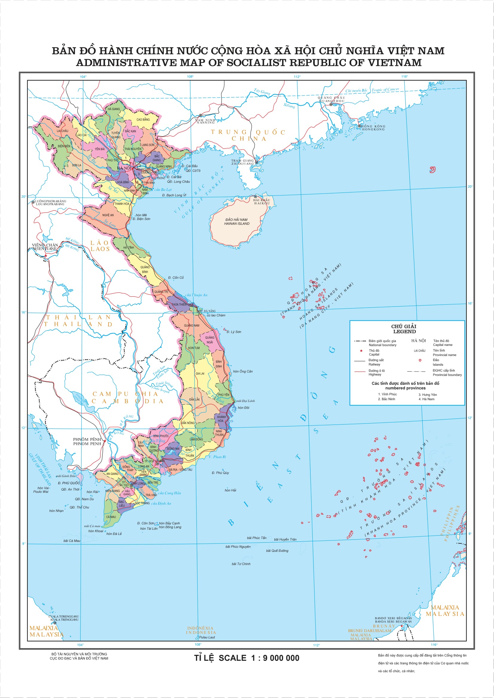
Historically, issues related to territorial sovereignty, especially regarding the Hoang Sa and Truong Sa Islands, which are under Vietnam’s lawful sovereignty, are sensitive matters. China’s illegal occupation of some islands in this area has always been a highly sensitive issue. As a specialized provider of map data and Maps API services in Vietnam, Goong is dedicated to building a “Made in Vietnam” digital map system, emphasizing the importance of addressing these issues.
In this article, let’s explore the issues surrounding territorial sovereignty and the legal regulations concerning the use of map data that infringes upon Vietnam’s maritime sovereignty.
The legal and practical basis affirm Vietnam’s sovereignty over the Hoang Sa and Truong Sa Islands.
The Paracel and Spratly Islands of Vietnam are currently the focal point of complex disputes among some coastal nations in the East Sea. In terms of resolving territorial sovereignty disputes, international law has established the principle of sovereignty based on actual occupation and the exercise of state power in a genuine, continuous, and peaceful manner. This principle has been applied by many countries and international judicial bodies to settle numerous territorial sovereignty disputes worldwide.
Applying the above-mentioned principle of international law to the case of the Hoang Sa and Truong Sa Islands, historical evidence and legal basis have consistently shown that the Vietnamese state, historically and up to the present, has exercised sovereignty over these islands, at least since the 17th century, when these islands did not belong to any other country. Vietnam has continually and peacefully established and exercised its sovereignty over the Hoang Sa and Truong Sa Islands.
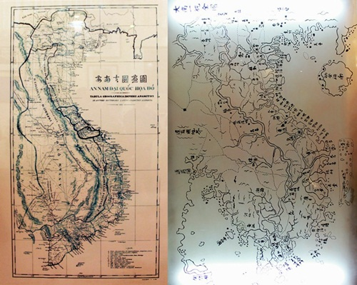
These activities are documented in numerous historical records like “Toan tap Thien Nam Tu chi lo do thu” by Do Ba Tu Cong Dạo (1686) and “Phu bien Tap luc” by Le Quy Don (1776) among others. Many other historical documents such as “Lich trieu hien chuong loai chi” and “Hoang Viet du dia chi” provide even clearer descriptions of Vietnam’s management of the Hoang Sa and Truong Sa Islands.
Vietnam has numerous historical documents affirming sovereignty over these two island groups. Importantly, is that all of them align with reliable foreign documents.
Notably, there are numerous maps and geographical books from Vietnam’s ancient past, such as “Giap Ngọ Binh Nam Do” (1774), “Dại Nam thuc luc chinh bien” (1848), “Dai Nam Nhat Thong chi” (1882),….
Learn more: https://goong.io/tin-tuc/du-lieu-ban-do-thieu-chinh-xac-van-tai-cong-nghe-lao-dao/
The historical documents preserved, despite enduring wars and losses over the past centuries, as well as affirmations from numerous international conferences such as the Cairo Conference (1943), the Potsdam Conference (1945), the San Francisco Conference (1951), the Geneva Conference (1954), the Paris Peace Accords (1973), along with the ruling of the Permanent Court of Arbitration (07/2016) in the Philippines vs. China case on the South China Sea, provide more than enough factual and legal basis for Vietnam to assert sovereignty over the Hoang Sa and Truong Sa Islands. These foundations dismiss entirely any unfounded claims by China regarding the South China Sea. China, with its expansionist and greedy ideology, has conducted blatant and confrontational actions, such as asserting the so-called Nine-Dash Line doctrine (also known as the Cow Tongue Line), illegally occupying some islands in both the Truong Sa and Hoang Sa Islands of Vietnam. This is seen as a black-and-white reversal, showing contempt for international law.
The regulations on penalties for violations involving the use of inaccurate maps, map data, or actions that infringe on Vietnam’s territorial sovereignty.
So, how do current legal regulations address penalties for entities using maps or map data that infringe upon Vietnam’s island sovereignty? What are the supplementary penalties and remedial measures? Let’s explore this further with Goong.
Based on Clause 2, Article 11 of Decree 18/2020/NĐ-CP, it states:
“Violations regarding the publication and circulation of surveying and mapping products, the publication of maps…”
A fine ranging from 30 million VND to 40 million VND is imposed on the act of circulating surveying and mapping products, and publishing map products related to national territorial sovereignty without depicting or inaccurately depicting the sovereignty and national borders as regulated by the law on surveying and mapping.
The fine level specified in Chapter II of this Decree is the fine level for individuals violating administrative regulations and the fine level for organizational violations is twice the fine for the same administrative violation conducted by an individual.
Therefore, an organization engaging in the circulation and use of maps infringing upon national territorial rights, without depicting or accurately depicting island sovereignty and national borders as stipulated by the law on surveying and mapping, is one of the violations concerning the publication and circulation of surveying and mapping products, and publishing map products and could be fined up to 80 million VND.
Sanctions for Administrative Violations Regarding Organizations Using Maps Infringing Upon Vietnam’s Island Sovereignty
In addition to the aforementioned primary sanctions, the law also clearly stipulates supplementary sanctions for this behavior as follows:
Seizure of exhibits, means of violating administrative regulations for acts specified in Clauses 2 and 3 of this Article;
Foreign individuals who commit administrative violations as stipulated in Clauses 2 and 3 of this Article may, depending on the severity of the violation, be subject to the supplementary sanction of expulsion from the Socialist Republic of Vietnam.
Therefore, in addition to being fined, organizations engaged in the circulation and use of maps related to the national territorial sovereignty of Vietnam, without depicting or inaccurately depicting island sovereignty and national borders as regulated by the law on surveying and mapping, will have the relevant exhibits and means of administrative violation seized.
Remedial Measures for Organizations Using Maps Infringing Upon Vietnam’s Island Sovereignty
In addition to administrative penalties and supplementary sanctions, what are the remedial measures?
Based on Clause 5 of Article 11 of Decree 18/2020/NĐ-CP, as amended and supplemented by Clause 8 of Article 4 of Decree 04/2022/NĐ-CP, it is stipulated as follows:
“Violations regarding the publication and circulation of surveying and mapping products, the publication of maps…
Remedial measures:
- Compulsory correction of information, data, surveying and mapping products, and map products for the acts specified in Clauses 1 and 2 of this Article;
- Compulsory retrieval of data, surveying and mapping products, and map products for acts specified in Clauses 2 and 3 of this Article;
- Compulsory destruction of surveying and mapping products, and map products for the acts specified in Clauses 2 and 3 of this Article;
- Compulsory repayment of illegal profits obtained;
- Compulsory return of licenses and professional certificates to the issuing authority for engaging in the acts specified in Clauses 2 and 3 of this Article.
Therefore, organizations engaging in the circulation and use of maps related to the national territorial sovereignty of Vietnam, without depicting or inaccurately depicting island sovereignty and national borders as regulated by the law on surveying and mapping, will be required to remedy the consequences, including:
- Compulsory correction of information, data, surveying and mapping products, and map products;
- Compulsory retrieval of data, surveying and mapping products, and map products;
- Compulsory destruction of surveying and mapping products, and map products;
- Compulsory repayment of illegal profits obtained;
- Compulsory return of licenses and professional certificates to the issuing authority.
For Goong, as a provider of map data in Vietnam, we always strive to create the most accurate map products, providing users with a comprehensive digital map platform containing complete data information about the islands, contributing to affirming Vietnam’s territorial sovereignty.
Let’s join Goong in spreading the widely-used “Made in Vietnam” digital map platform – not only for the Vietnamese people but also to assert Vietnam’s sovereignty over its islands internationally at: https://account.goong.io/login